
Asia Wall Map (Revised) by Maps International
| Barcode | 9781904892021 |
|---|---|
| ISBN | 9781904892021 |
| Format | Maps |
| Publisher | Maps International |
| Size | 1200 x 1000 mm |
| Weight (g) | 300 g |
Product description
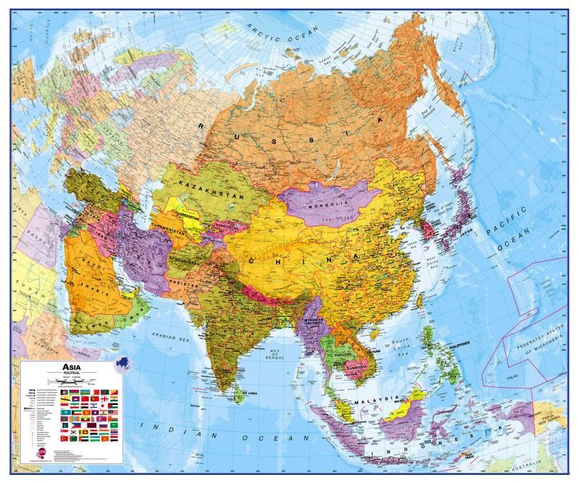
Maps International's political wall map of Asia shows all countries from Turkey in the West to Japan in the East, down to Indonesia in the South of Asia. The largest and most populated continent, Asia has a lot to fit onto a map! Rest assured though, with Maps International's high quality of mapping nothing is missed out!
This political wall map of Asia features countries marked in different colours, with international ...
Read More
![]()
Maps International's political wall map of Asia shows all countries from Turkey in the West to Japan in the East, down to Indonesia in the South of Asia. The largest and most populated continent, Asia has a lot to fit onto a map! Rest assured though, with Maps International's high quality of mapping nothing is missed out!
This political wall map of Asia features countries marked in different colours, with international borders clearly shown. The map's key shows the flags from the countries displayed in this map. This Asia physical wall map also contains city population detail, capital cities and all the major towns and cities in this continent of Asia.
Maps International's Asia map is available either plain or laminated. Ideal size for an office or classroom.
Show LessGloss Laminate
Gloss laminate makes colours look more vibrant and stand out more, but is quite shiny (reflective). If you’re planning on using a marker of any sort, this is a better choice because it’s easier to clean. Your print will be fully encapsulated (so laminated on both sides) in durable 80 micron laminate and will last you a lot longer than plain paper.
Matte Laminate
Matte laminate has a smooth, non-reflective, very classy looking surface. I wouldn’t say it dulls colours, but it doesn’t make them ‘pop’ (I hate that I just used that word) in the way that gloss does. Matte can be drawn on with pencil (and erased), but is harder to clean if you use markers. Your print will be fully encapsulated (so laminated on both sides) in durable 80 micron laminate and will last you a lot longer than plain paper.
Canvas
Everything looks better on canvas! Something about the texture really makes prints look wonderful. It is quite expensive though. We use a very high quality 340gsm artistic matte canvas. Your canvas print will come rolled with a roughly 50mm white border to allow you to have it stretched or mounted however you wish.
| Barcode | 9781904892021 |
|---|---|
| Isbn | 9781904892021 |
| Format | Maps |
| Publisher | Maps International |
| Size | 1200 x 1000 mm |
| Weight (g) | 300 g |


