
Melbourne & Region Wall Map by Hema Maps
| Australia region | Victoria |
|---|---|
| ISBN | 9781925195613 |
| Format | Maps |
| Publisher | Hema Maps |
| Retail express code | 125079 |
| Size | 700 x 1000mm |
| Weight (g) | 200 g |
Product description
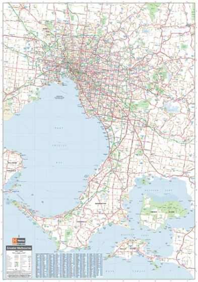
A laminated map of Melbourne and the surrounding region that is ideal as a reference and for planning sales and delivery zones. The mapping features suburbs and postcodes, marked camping areas, caravan parks, fuel supplies, major national parks and an index.
The map covers from Phillip Island in the south, to Werribee in the west, to Sunbury in the north and Pakenham in the east.
- Easy-to-read cartography
- Wall map ... Read More
A laminated map of Melbourne and the surrounding region that is ideal as a reference and for planning sales and delivery zones. The mapping features suburbs and postcodes, marked camping areas, caravan parks, fuel supplies, major national parks and an index.
The map covers from Phillip Island in the south, to Werribee in the west, to Sunbury in the north and Pakenham in the east.
- Easy-to-read cartography
- Wall map
- Index
- Postcodes
Gloss Laminate
Gloss laminate makes colours look more vibrant and stand out more, but is quite shiny (reflective). If you’re planning on using a marker of any sort, this is a better choice because it’s easier to clean. Your print will be fully encapsulated (so laminated on both sides) in durable 80 micron laminate and will last you a lot longer than plain paper.
Matte Laminate
Matte laminate has a smooth, non-reflective, very classy looking surface. I wouldn’t say it dulls colours, but it doesn’t make them ‘pop’ (I hate that I just used that word) in the way that gloss does. Matte can be drawn on with pencil (and erased), but is harder to clean if you use markers. Your print will be fully encapsulated (so laminated on both sides) in durable 80 micron laminate and will last you a lot longer than plain paper.
Canvas
Everything looks better on canvas! Something about the texture really makes prints look wonderful. It is quite expensive though. We use a very high quality 340gsm artistic matte canvas. Your canvas print will come rolled with a roughly 50mm white border to allow you to have it stretched or mounted however you wish.
| Australia region | Victoria |
|---|---|
| Isbn | 9781925195613 |
| Format | Maps |
| Publisher | Hema Maps |
| Retail express code | 125079 |
| Size | 700 x 1000mm |
| Weight (g) | 200 g |


