
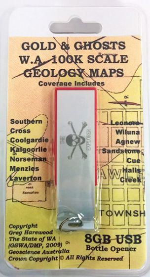
Gold & Ghosts WA 100K Scale Geology Maps USB (2nd Edition) (2009)
| Australia region | Western Australia |
|---|---|
| Barcode | 9321438102366 |
| ISBN | n/a |
| Format | Maps |
| Publisher | Greg Harewood |
| Retail express code | 135397 |
| Size | 85 x 135 x 10mm |
| Weight (g) | 95 g |
Product description
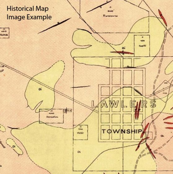
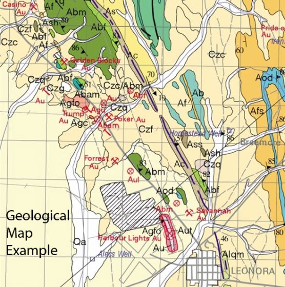
The Gold and Ghosts 100K Geology & Historical Mine and Lease Map set (supplied on 8GB USB thumb drive, with a bottle opener!) contains 223 Geology maps (100K scale) and 151 historical map images (various scales) covering significant portions of Western Australia's various goldfields.
The Geology maps have been geo-referenced and converted into OziExplorer format (OZF2) and ECW format and can be viewed with a range of GPS mapping programs ...
Read More
![]()
The Gold and Ghosts 100K Geology & Historical Mine and Lease Map set (supplied on 8GB USB thumb drive, with a bottle opener!) contains 223 Geology maps (100K scale) and 151 historical map images (various scales) covering significant portions of Western Australia's various goldfields.
The Geology maps have been geo-referenced and converted into OziExplorer format (OZF2) and ECW format and can be viewed with a range of GPS mapping programs such as the various versions of OziExplorer (PC, CE and Android), TwoNav, TrackRanger and various GIS programs such as ArcView and MapInfo. In some cases conversion of the image format may be required but typically conversion programs are provided by respective software manufactures. For example MudMap provide a conversion program on their website to convert ECW image files to their native MM format along with calibration information.
Also included on the USB is an abandoned gold mine/workings name search databases containing in excess of 70,000 records. The name search function in OziExplorer can be used to locate the position of historical mines and abandoned workings (shafts, adits, costeans etc) by name and/or by map sheet..
Coverage Includes:
- Southern Cross
- Coolgardie
- Kalgoorlie
- Norseman
- Menzies
- Laverton
- Leonora
- Wiluna
- Agnew
- Sandstone
- Cue
- and areas in between
- Plus Halls Creek area & parts of the Pilbara.
The map images supplied on the USB have been sourced from the WA State Department of Mines and Petroleum. The 100K geology maps range in age from the late 1980s to 2013. The historical maps range in age from the late 1890s to the 1940s and include geology maps, lease maps and plans of underground shafts.
NOTE: Maps are in OZF and ECW format to be utilised by compatible Map Viewing Software, Applications, or GPS systems (must be able to read raster map files).
Show Less| Australia region | Western Australia |
|---|---|
| Barcode | 9321438102366 |
| Isbn | n/a |
| Format | Maps |
| Publisher | Greg Harewood |
| Retail express code | 135397 |
| Size | 85 x 135 x 10mm |
| Weight (g) | 95 g |


